









Alla auktioner / Böcker, Kartor och Texter / Czechia - Prague

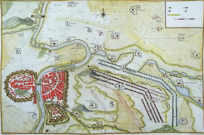
Plan de La Bataille, gagnée par Sa Majeste' le Roi De Prusse, sur l'Armée Autrichienne, aux Ordres de S. A. R. le Duc Charles de Lorraine, près de Prague; le 6 May 1757. (1758) Image 37,5x44,5cm, sheet 42x51cm Striking and highly detailed fine unusual copper engraved military map illustrating the plan of the Battle of Prague (also known as the Battle of Štěrboholy), fought on May 6, 1757, during the Seven Years' War, by Pierre de Hondt after L. W. F. Von Oebschelwitz, engraved by J. V. Schley. Here are the main details that can be gleaned from the document: Victor: The Prussian army led by Frederick the Great. Loser: The Austrian army under the command of Charles Alexander of Lorraine. It was one of the bloodiest battles of the 18th century, marked by a daring Prussian flanking maneuver through marshy terrain. Map Elements The map is oriented with North up (as indicated by the compass rose in the center) and shows: The city of Prague: Clearly visible on the left, surrounded by its imposing star-shaped fortifications. The Vltava River: Meandering through the landscape, dividing the operational areas. Military Deployments: The colored blocks represent infantry and cavalry formations. Red lines usually indicate the Prussians, while blue or yellow (depending on the specific map convention) indicate the Austrians. Topography: The hills (Ziska), surrounding villages, and small bodies of water or marshy areas that played a crucial tactical role are clearly visible. Legend and Critical Apparatus The lower section features an extensive legend (Renvois) with alphabetical (A-T) and numerical (1-9, I-VI) references explaining: Troop movements during the various phases of the battle. The positions of the pontoon bridges built to allow for river crossings. The names of key villages (such as Štěrboholy) where the heaviest fighting took place. Good condition. Top margin short, leaving the top of the title cut off, some minimal age browning in the bottom margin. Otherwise excellent. Central fold as published, clear print, nice hand coloring, thick paper.
Utropspris:SEK 1,892.76
Till auktionenVisa alla föremål frånCatawikiellerBöcker, Kartor och Texter
Utropspris:
SEK 1,892.76


KARTA ÖVER ASIEN, HOMANN ca 1730.
10/29/2026
SEK 1,800
Uppsk.: SEK 2,500

BAND - ARISTOTELES, Lyon 1579, endast del 2.
10/29/2026
SEK 600
Uppsk.: SEK 1,000

BÖCKER OM KVINNLIGA KONSTNÄRER, BIRGIT RAUSING, TRE STYCKEN.
10/29/2026

SEK 851
Uppsk.: SEK 800
Nå samlare över hela världen med din auktion!
Lista er auktionGenom att prenumerera godkänner du integritetspolicyn. Avprenumerera när som helst.
Barnebys HQ
Brahegatan 10
BOX 5038
114 37 Stockholm
