John Henry Alexander's Manuscript Maps of Maryland - The Single Most
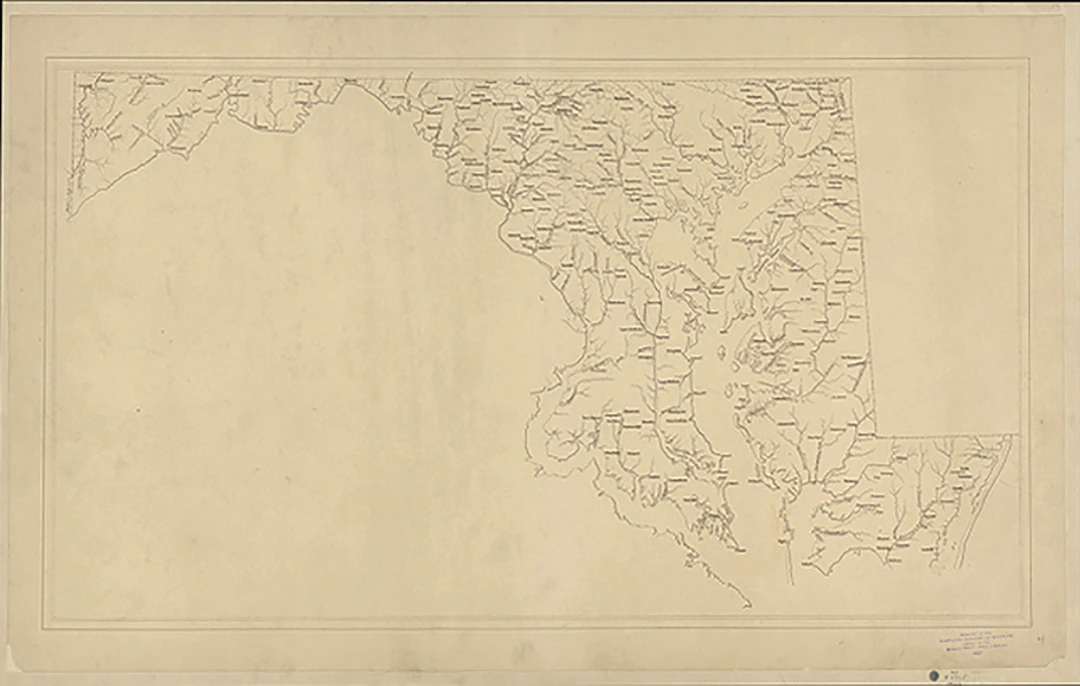
ALEXANDER, John Henry (1812–1867). Eleven maps of Maryland: nine manuscript and two lithographed. 1833-1837. Each map with marginal pencil shelfmarks as well as inkstamps from the Enoch Pratt Free Library. Manuscript map of Washington and Frederick Counties. Single sheet (19 ½” x 27 ¼”), laid down on linen. Ink and wash. Manuscript map of the District of Columbia and Anne Arundel, Montgomery and Prince George’s Counties. Single sheet (19 3/8” x 20 ½”), laid down on linen. Ink and wash. Manuscript triangulation map of the northeastern part of the Atlantic Coastal Plain and the Piedmont Plateau. Single sheet (21 ¾” x 29 ½”), laid down on linen. Graphite and red and black ink. Manuscript map of Dorchester, Somerset and Worcester Counties. Single sheet (19 ½” x 27 ½”), laid down on linen. Ink and wash Manuscript map of Kent, Queen Ann, Talbot and Caroline Counties. Single sheet (19 ½” x 17 ¼”), laid down on linen. Ink and wash. Manuscript map of Calvert, Charles and St. Mary Counties. Single sheet (19 ½” x 27 ¼”), laid down on linen. Ink and wash. Manuscript map of Allegany County (including modern Garrett County). Single sheet (19 ½” x 27 ½”), laid down on linen. Ink and wash. Manuscript map of Baltimore, Harford and Cecil Counties. Single sheet (7 ¾” x 12 3/8”). Graphite. Manuscript map of the state of Maryland. Single sheet (16 ¼” x 28”), laid down on linen. Ink. Map, shewing the proposed Division of the Counties of Howard and Anne-Arundel. Baltimore: Edward Weber, [ca. 1837]. Single sheet (10 1/8” x 18 ½” to the neatline, 13” x 22” sheet). Lithograph. Map showing the proposed new Carroll (“Carrol”) County and its surroundings. Baltimore: J. Penniman, [ca. 1835]. Single sheet (5 1/8” x 9 1/8” to the neatline, 16” x 10” sheet). On the verso, the text of the petition. [Individual condition reports available.] In 1833, John Henry Alexander (1812–1867), twenty-one and already some years graduated from St. John’s College in Annapolis, was commissioned by the Maryland General Assembly to survey and map the whole of its state for topographical and census purposes. Alexander as State Topographical Engineer with his friend Julius Ducatel, State Geologist, mapped the whole of the state with exceptional accuracy (not to be surpassed till the introduction of satellites), issuing county-by-county surveys with the General Assembly’s annual reports through 1840. The present manuscript maps are the basis for those printed and published maps; essentially fair copies in preparation for the maps included in the annual reports. Although the project for publishing a highly accurate map of the whole state was never completed, Alexander’s extraordinary achievement is surely the largest contribution made by an individual to the mapping of a state. Of particular note are the triangulation map (3) and the pencil manuscript map of Baltimore, Harford and Cecil counties (8). The small pencil map (8) shows an earlier phase of the mapmaking process; it would be enlarged and inked once it had been reviewed. Triangulation was the most accurate method of mapmaking up until satellite surveys; Alexander proposed to build on the work of the United States Office of Coast Survey, founded 1807 and re-established in 1832, which used the same method, but was sluggish in reaching Maryland. The general trigonometric plan is visible in map 3, but Alexander would not have the opportunity to bring it down to the county level. When funding stopped in 1841, he abandoned the project, and focused his efforts on his highly profitable coal mines in the western part of the state. (The Library of Congress holds a single three-sheet manuscript map of Alexander’s (LCCN 77693816) from 1840, summing up all the work that had been done up to that point.) Alexander’s maps would come to be of immense use in the Civil War in order to mount the defense of Washington, D.C. The collection of maps was given anonymously to the Maryland Academy of Sciences in January of 1878, though it is generally understood that the donor was the widow of Philip T. Tyson, the State Agricultural Chemist, who in 1859 brought to completion the geological survey that had stopped with Ducatel’s death in 1849. The Maryland Academy of Sciences deposited the collection with the Enoch Pratt Free Library in Baltimore in 1937; the inkstamps and shelfmarks are from their collection. Papenfuse, Edward C. and Joseph M. Coale III. The Maryland State Archives Atlas of Historical Maps of Maryland 1608–1908. Baltimore: The Johns Hopkins University Press, 2003; 67-70.
Utropspris:SEK 2,975,415
Till auktionenVisa alla föremål frånArader GalleriesellerBöcker, Kartor och Texter